Most project teams have seen a plan covered in coloured lines for water, sewer, stormwater, electrical, gas and communications. It’s easy to assume every line has been checked to the same standard. Often that isn’t true.
One line might come from a decades-old as-built drawing. Another might be inferred from a pit lid. A third might have been detected in the field with locating equipment and then surveyed. They can look the same on paper, but they don’t carry the same level of certainty.
That’s the problem AS5488 helps solve. The Australian Standard for classifying subsurface utility information is now published in two parts: AS 5488.1 and AS 5488.2, both revised in 2022. It gives a common way to describe how reliable information about underground services is. The core of it is a set of quality levels: QL-D, QL-C, QL-B and QL-A.
What are AS5488 quality levels?
Each quality level shows how the information about a utility was obtained, and how far it can be relied on. Here is a simple summary:
- QL-D: Information taken mainly from existing records. This includes asset-owner plans, as-built drawings, old site plans and anecdotal information. It’s useful for knowing what might be there, but it hasn’t been checked in the field.
- QL-C:Information based on visible surface features, such as pits, valves, hydrants, kerb markers and service poles, linked to existing records. Seeing a pit lid confirms something is there, but the path of the service between surface features is still largely assumed.
- QL-B: The utility has been detected and traced using suitable geophysical locating methods, and its position has then been surveyed. This is the first level where the underground alignment has actually been detected in the field.
- QL-A:The highest level of verification. The utility is usually exposed or accessed directly, for example by vacuum excavation (non-destructive digging) or potholing, so its actual position can be confirmed and surveyed.
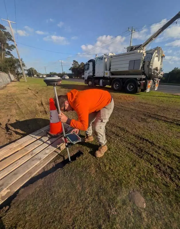
(Surveying a service exposed by vacuum excavation. Physically exposing the utility is the kind of verification associated with QL-A.)
The Standard also sets out the attributes and positional tolerances that go with each level. This article only gives a practical overview. For contract or compliance purposes, refer to the current Standard itself, as this isn’t legal or contractual advice.
What does QL-B actually mean?
QL-B is often the most practical quality level for design, investigation and pre-construction work. The key difference from QL-D and QL-C is simple: the service has been detected in the field, not just copied from a plan or inferred from the surface.
A QL-B investigation may use several methods, depending on the utility and the site:
- Electromagnetic (EM) locating: Traces conductive services such as metallic pipes and cables. It can work passively or by applying a signal directly to the utility.
- Ground penetrating radar (GPR):Picks up changes below the surface. It can help find non-metallic services and features that EM can’t detect, depending on ground conditions.
- Trace rods: Flexible rods with a conductive core are pushed through non-metallic pipes, such as stormwater, sewer or conduits, and then traced from the surface.
- Sondes: Small transmitters inserted into a pipe or attached to a rod, so its route can be followed from above ground.
- Drainage and pipe tracing:Working between pits, outlets and access points to confirm connections, routes and changes in direction.
- Surveying the detected position: Recording the located utility with survey equipment, so it can be shown accurately on a plan and in CAD.
No single method suits every situation. The right approach depends on the type of utility, what it’s made of, whether there are access points, and site conditions such as soil type, moisture and surface cover. A good QL-B investigation often combines several of these methods.
Does QL-B mean the service position is exact?
No. QL-B means the utility has been detected and its position surveyed, within the limits of the locating methods and the site. It doesn’t mean the exact physical position can be assumed without allowing for tolerances and conditions.
Several factors affect how well a service can be located:
- Depth: Deeper services are generally harder to detect, and depth estimates become less certain.
- Soil conditions: Clay, high moisture, fill and reactive soils can weaken GPR signals and affect EM results.
- Congestion:Where many services run close together, signals can overlap and be hard to separate.
- Non-conductive pipes: PVC, polyethylene, concrete and earthenware pipes can’t be traced with EM unless there is a tracer wire or an access point for a rod or sonde.
- Poor or missing access: Buried, damaged or missing pits limit the methods available.
- Interference: Nearby metal structures, reinforced concrete, fences and overhead power can affect readings.
- Unusual or abandoned infrastructure: Redundant services, unrecorded connections and old structures may not behave as expected, or may not appear on any record.
A clear utility survey will state any limitations like these. Where exact confirmation matters, for example at a proposed excavation near a high-risk asset or where clearances are tight, QL-A verification by non-destructive digging may be appropriate.
What’s the difference between QL-B and BYDA plans?
Before You Dig Australia (BYDA, formerly Dial Before You Dig) is an essential first step on almost any project. Asset-owner plans show which utilities may be present and who is responsible for them.
These plans are generally record information, though. They show what the asset owner holds on file, often at a scale and level of detail that suits network management rather than site design. They usually don’t include private services within a property, such as internal stormwater, site electrical or irrigation.
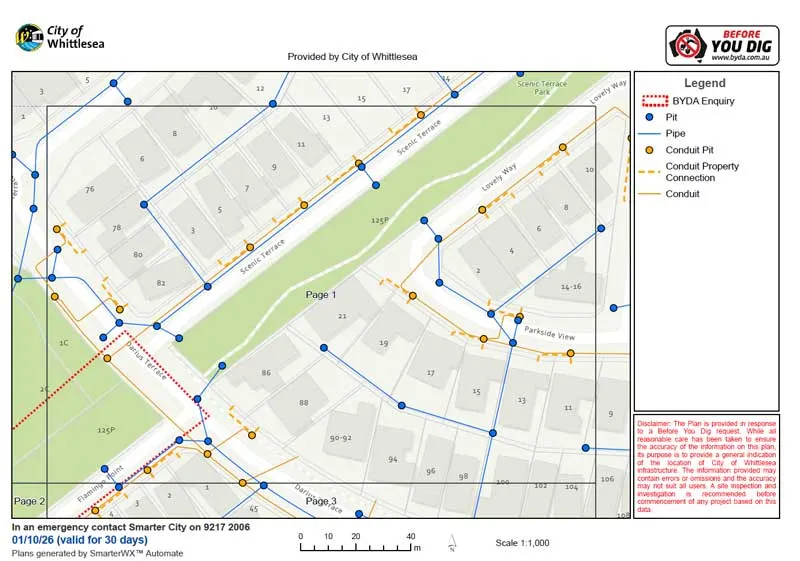
(An example Before You Dig Australia plan. Plans like this are valuable record information, and the asset owner’s own disclaimer recommends a site inspection and investigation before work begins.)
BYDA plans and a QL-B utility survey work together. Record information shows what to look for, and field locating and surveying confirm what can actually be detected on site.
When might a client request QL-B?
QL-B utility locating is commonly requested before:
- excavation and trenching
- installing light poles, signs or footings
- drainage works
- new buildings and extensions
- roadworks and car park upgrades
- landscaping
- service connections
- civil design
- directional drilling and bore paths
- retaining walls
In each case, knowing where existing services are detected, rather than just recorded, supports better design decisions and safer excavation planning.
What should the final utility survey include?
Deliverables depend on the scope, but a useful utility survey may include:
- surveyed utility positions
- utility type and, where identifiable, owner or function
- indicative or measured depths where obtainable
- pits, valves and other surface features
- quality level classifications for each utility
- CAD/DWG files for designers
- PDF plans for site use
- survey coordinate and level information
- notes, limitations and assumptions
- orthomosaic or other site imagery where useful
The notes and limitations are as important as the linework. They tell the reader what was and wasn’t detected, and why.
How we approach a utility survey
Locating a service is only half the job. The survey that records it matters just as much. A well-located utility drawn on a poorly controlled survey loses much of its value. It may not line up with design files, other surveys or future work on the same site.
Our team has worked in the industry for decades, and that experience shapes a consistent, repeatable method for every job.
Survey control you can come back to. Our GNSS survey method is based on the principles in the Survey Practice Handbook published by the Surveyors Registration Board of Victoria, alongside current Surveyor-General Victoria guidance. Before we pick up any utilities, we find and occupy nearby published third-order permanent marks (PMs) and observe each one for about a minute. We compare our GNSS results with the published values, and differences of around 50 mm are typical. We then correct for that difference. This places the survey on a known, repeatable datum, MGA2020 for position and AHD for height, tied to the state survey control network. In years to come, future project teams, designers and surveyors can tie back to the same reference with confidence.
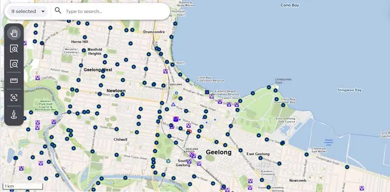
(Published survey marks around Geelong in the Survey Marks Enquiry Service (SMES). Marks like these provide the known control our GNSS surveys are checked against and adjusted to.)
Knowing the quality of the survey itself is just as important as knowing the quality of the utility information.
Quality levels assigned in the field. Each utility is attributed as QL-A, QL-B, QL-C or QL-D on site at the time of survey, by the people who located it. We don’t leave the classification to be guessed later in the office.
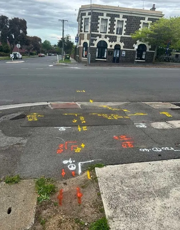
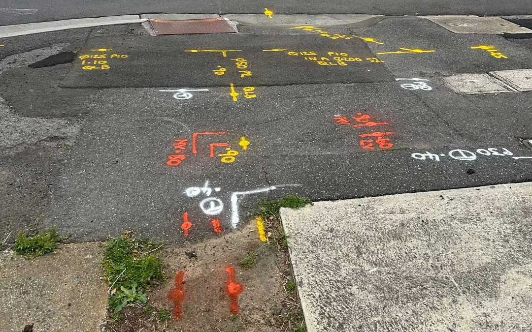
(A completed field mark-out, with the quality level noted on the ground alongside each located service.)
Drafting that shows the quality.The field data is reduced and drafted using our own drafting system, which we have built up over years of work. Linestyles are labelled by quality level, so anyone reading the plan can see at a glance how reliable each line is.
QA between locator and surveyor. Before a plan is issued, the certified locator and the surveyor review the drafted survey together in a live shared-screen session. They check it against what was found on site, so nothing is missed or misrepresented.
The result is utility information that clients can rely on for their next step, whether that’s trenching, excavation or network design.
Conclusion
When planning design or construction near underground services, “Have the services been located?” is only part of the question. The more useful question is: “What quality of information do we actually have?” That includes the quality of the survey behind it.
Knowing the difference between QL-D, QL-C, QL-B and QL-A helps project teams judge risk, set the right scope and know when more verification is needed. If you’d like to discuss the level of information your project needs, the Geoscan team is happy to help.